
Tag: bridge
-
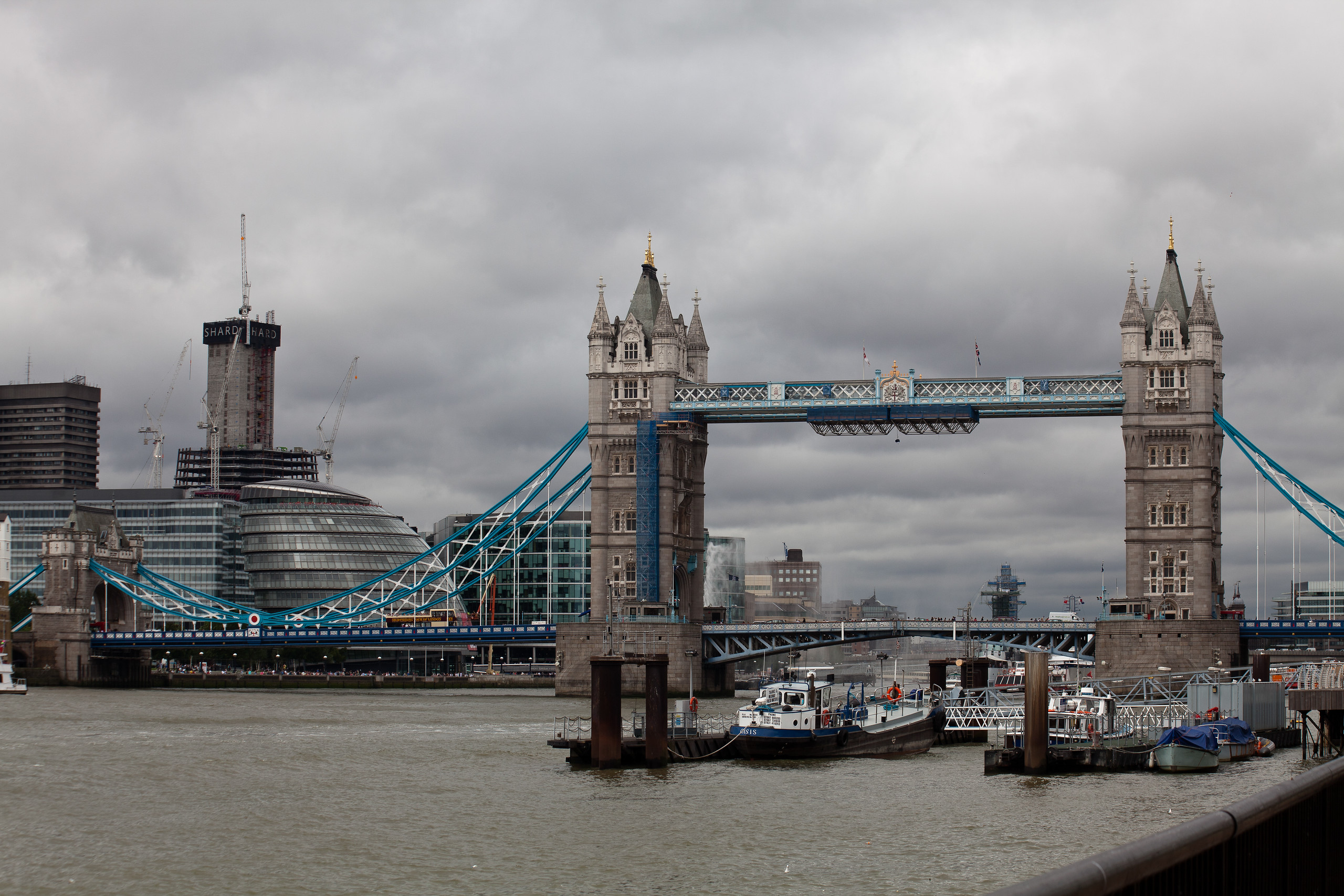
Tower Bridge
The famous tower bridge in East London, England. Click on the link to view a larger version. -
African shoestrings – Zambia Day Eighty Four Livingstone
Victoria Falls (known locally as “the mist that thunders”) is one of the great natural beauties of the world. A quirk of political geography has put just over half of the falls in Zambia but three quarters of the viewing area in Zimbabwe. Consequently the views from both countries are a lot different. After having been dropped off by the Fawlty Towers shuttle; we strolled into the Mosi-oa-Tunya National Park, where the Zambian viewpoints are located, past the many curio stalls that we decided we would look at later and straight into mist!
Let me see if can set the scene for you…………… Imagine if you can the mighty Zambezi, a wide stretch of water, sweeping down from its source in North Western Zambia some 900 kilometres away, plunging down a 103 metre high and 1600 metre wide precipice into a narrow gorge which turns at right angles on the Zambia border into an even narrower channel and out into a slightly wider gorge as if unaffected by its trauma of the last 2 kilometres of its journey. From a huge wide open river, the Zambezi hits Victoria Falls and changes its identity into a body of water flowing through a series of narrow and deep gorges. The Zambian viewpoints are all at the point of convergence of water from the Zimbabwean side meeting water from the Zambian side and then somehow squeezing into that first narrow channel. It is here that great volumes of water thunders down and then rises up in the form of mist, hence the name “The mist that thunders” and then drenches everything in sight including us! Last time we had been there the water level had been a lot lower and we managed to stay relatively dry in comparison. This time we only succeeded in keeping the camera dry as we wondered from point to point beginning to look like drowned rats.
When the rains have been good its estimated about 5 Million cubic metres of water per minute passes over the falls and I’m sure it was all falling on top of us! There’s one particular point called appropriately Knife Edge Bridge. It’s a wooden footbridge that crosses from the mainland to a tiny island in the Zambezi. Walking across is about as close as you get to walking through the falls itself. Needless to say we could see nothing but feel plenty. In the end we gave up and found a trail that led down to the water’s edge downstream of the falls. It was called Boiling Point and it’s here that you can see a great swirling mass of water resembling a watery black hole generated by the pounding that is happening a few 100 metres upstream. It’s also here that the best view of the Zambezi Bridge is to be had. It joins the two countries and hosts two sets of customs and immigration, a continuous human chain crossing both ways and Bungy Jumping.
Look I hope that I’m not offending too many die-hard Bungy jumpers here but why? Why would anyone of sound mind and body attach an ankle to a glorified lackey band and jump off a 100 metre plus cliff, bridge or whatever, bounce up and down upside down for fun? A friend of ours did it and said that she had such an adrenalin rush that it stayed with her for a week. Well, let me tell you that’s one experience I’m happy to bypass. I get an adrenalin rush just from looking down (mind you that’s probably actually naked fear). Well anyway from our position I have to admit the jumpers looked spectacular jumping from the bridge. Small and almost insignificant against the backdrop of the huge gorge that houses both the bridge and the Zambezi but spectacular nonetheless.
If you like this then hit “follow” on the side bar
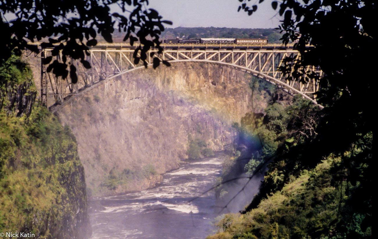
Victoria Falls and the Zambezi Bridge from the Zambia side Share this:
-
African shoestrings – Namibia Day Seventy-Six Botswana/Namibia
At Rundu we saw for the first time since the Fish River now some 1200 kilometres south a riverbed that actually had water! The Okavango River separates Namibia from the infamous Angola and was at the time experiencing its highest water levels for fifteen years. Considering that no other river in Namibia, except for the Orange River that separates Namibia from South Africa, has water in it, this was a sight for sore eyes. Well every silver lining has a cloud! Ngepi camp is on the river about 50 kilometres east of Rundu and the only access road to the camp was flooded due to the high river level. This meant we had to leave our comfy minibus and wade the final stretch through the overflowing river, a river know to have the odd croc or two!
The camp itself was a bush camp but with all the basic modern amenities in the form of open air toilets and showers separated by a bamboo walls and a pole barring the entrance to indicate if in use. Our tents had already been erected for us close to the riverbank, which was a lot steeper than where the road had passed it.
We were briefed on the next 6 days by Neil and then Paul and then after dinner Neil again. Neither of them were actually coming with us, Neil, a South African was the manager and Paul an American had just returned from the delta. I actually took an instant dislike to Paul; he took a holier than thou attitude as he explained that the tour was a local community based tour. By that he meant that the polers (I’ll explain this later) all came from the same village and using them to canoe tourists around the delta was a good way of helping the local communities and villages. He was quite right of course but he didn’t have to be such a prick about it!
We had heard that there were hippos and crocs in the Okavango but we didn’t expect to hear hippos chewing grass right outside our tents. Chomp! Chomp! They went all night or so Sue said the next morning. I slept through the whole thing!
At 7.30 am we were shunted onto an overland truck to pass through the flooded road and then loaded back into our minibus to drive onto our next destination, Sapepo on the Okavango Panhandle in Botswana. Crossing into Botswana was unremarkable except for one thing the Namibian border post building was a shameful shack in comparison to the brand new buildings at the Botswana post. Botswana is an expensive place to visit when it comes to national parks and reserves. It costs around US$25.00 per day per person in park fees unless you are part of guided group i.e. Safari. By comparison Etosha cost US$3.00! The Botswana government’s rationale is that they don’t want the mass tourism of Kenya so they spend very little on infrastructure in the parks and charge high fees to restrict the number of visitors. From our experience trying to independently travel through Botswana is not easy either, especially on a tight budget. There are many obstacles, like extremely limited public transport, and gaining access to the parks and reserves, so the vast majority of tourists end up touring Botswana with tour operators who know the country; but don’t stay any longer than they have to. So I guess so far its only partially working!
The Botswana/Namibia border was also the first place that we went through the passport swapping routine. This is not an illegal act of changing identity but simply changing nationality. So we gave Namibia our Aussie passport, that we had so far been using, for our exit stamp and Botswana our British passport for an entry stamp. Now bear with me why I explain why we did this. South Africa, Namibia and Botswana offer fee free visitors visas at the border for both Australian and British passport holders. Zambia charges British passport holders and Zimbabwe charges Australians however Zambia doesn’t charge anyone who enters the country with an official tour operator. This tour was going to leave us in Zambia from where we would cross the border into Zimbabwe. So why didn’t we just swap when we got to the Zimbabwe border? Well, a lot of third world countries don’t like this practice particularly if looks like it’s being done to avoid paying a fee (which it usually is of course). So it’s likely to be a lot less problematic if you choose to swap whilst in a group as the immigration officer is often too busy to check for an exit stamp from the adjoining country. As it happened the Namibian immigration officer did ask us on our way back a few days later, as to where our previous entry stamp into Namibia was. When we explained that we had used another passport he shrugged his shoulders and allowed us through. However as they don’t charge for visas I don’t suppose he cared.
Unfortunately the last part of this grand plan let us down. We knew that Tanzania required you to purchase a visa but it was cheaper to purchase in advance when traveling independently and we also knew that it cost US$50 for a British passport and only US$10 for an Australian. So when we went to the Tanzanian embassy in Harare two weeks later we obviously produced our Australian passports for stamping. We were politely told that they could only stamp the passport that we had used to enter Zim on. But we could take our chances at the border post when we arrived although there were no guarantees. Having experienced problems before at a Tanzanian border post four years ago we paid up and shut up and thus ended up worse off than if we had just used our Aussie passports throughout, which being the patriots that we are, was our preferred option.
If you like this then hit “follow” on the side bar
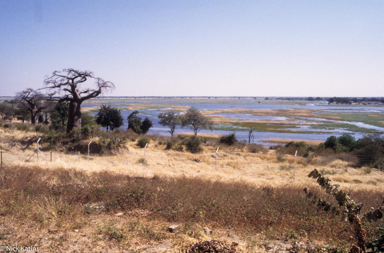
Ngoma bridge Border on the Chobe River Botswana and Namibia Share this:
-
Upper Slaughter in the Cotswolds photo
The village of Upper Slaughter in the Gloucestershire Cotswolds is one mile away from Lower Slaughter and sits on a gentle grassy slope above the stream that connects the two villages.
Once the village was dominated by a Norman castle but all that can be seen of it today are the remains of the motte and bailey.
This is quintessential Cotswolds in all its glowing golden beauty. The River Eye trickles its way through the hamlet on its journey to join the River Wind near Burton-on-the-Water, the river is so low here that the road runs through it at a ford and there is a series of tiny footbridges which enable residents and visitors to pass from one side to the other.
“Slaughter” was probably an Old English corruption of the Anglo-Saxon place-name “sclostre,” which means “slough” or “muddy place,” and that the family slaughter that owned the land and villages unusually took its name from the locality.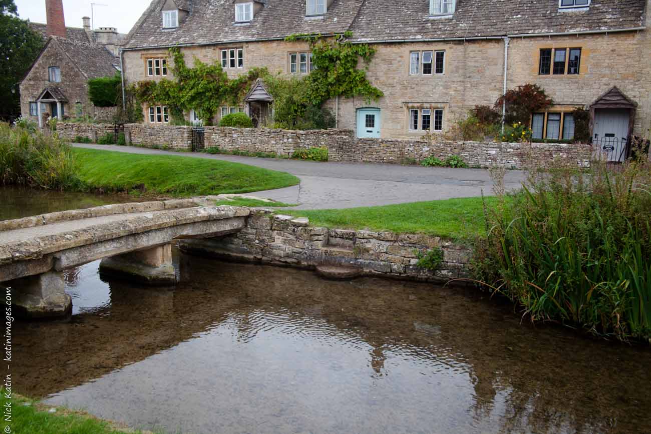
Upper Slaughter In the Cotswolds, England To see a larger image or to see purchase options click on the image
Share this:
-
Plaza de España -Seville, Spain
Built for the Spanish-American Exhibition of 1929, the Plaza de España is one of Seville’s top tourist attractions and why wouldn’t it be! With stunning architecture, inticate tiling and a calming semi circular lake, its just the place to go for a restful afternoon in the sun (provided it’s not too hot – Seville can have bitingly hot summer days).
One of it’s more modern claims to fame is that it has been used as a filming location. Scenes for the famous Lawrence of Arabia were shot here and the building was used as a location in the Star Wars movie series — Star Wars Episode I: The Phantom Menace (1999) and Star Wars Episode II: Attack of the Clones (2002).
I still have I have 10 free subscriptions from Zinio to give away. To enter visit zinio choose a magazine title and send me your first and last name and email address and if you want, send me your website address via the contact page or email. For more info go to Zino competition.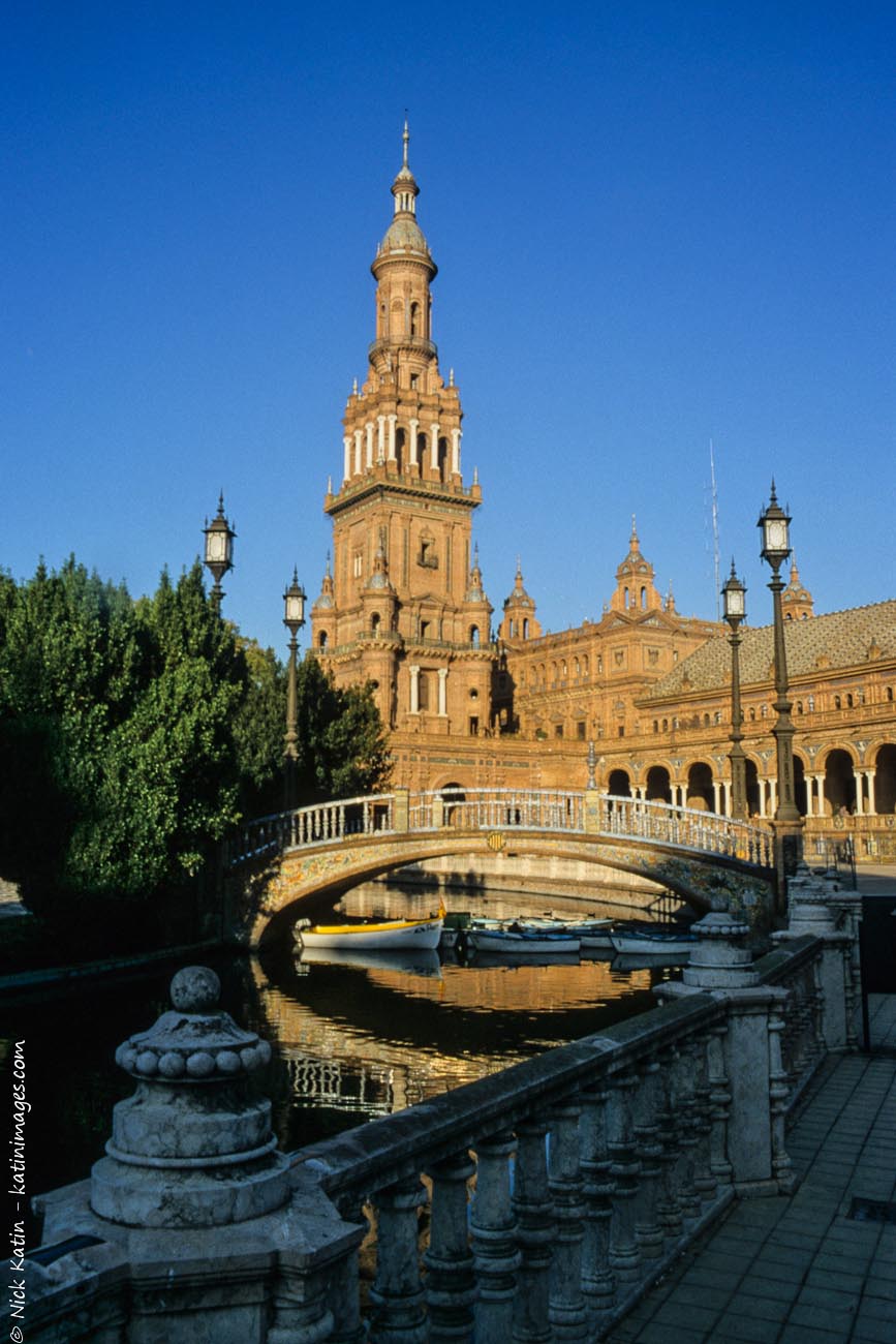
The Plaza de España, Spain Square, in English is a plaza located in the Parque de María Luisa, in Seville, Spain Share this:
-
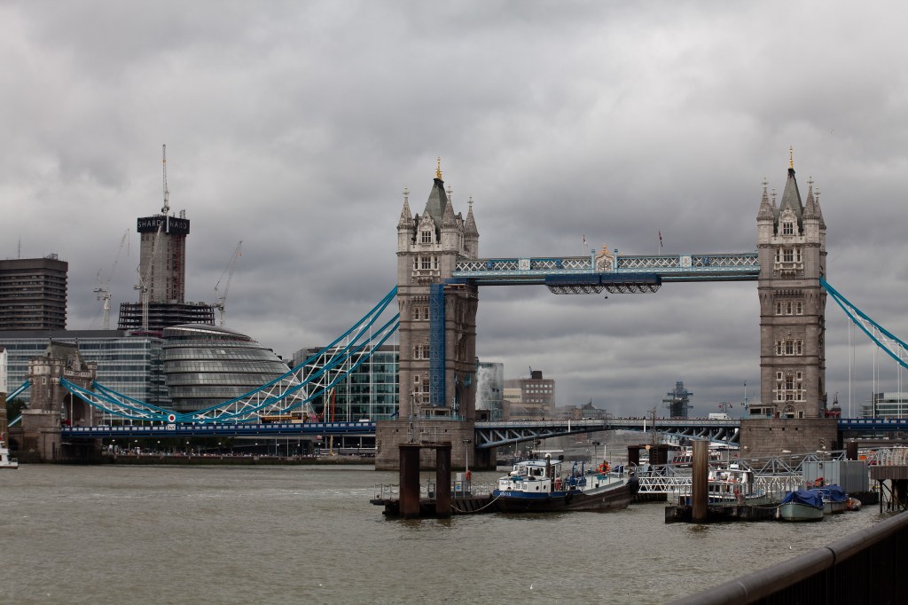
An atmospheric London Bridge photo
The famous London Bridge on a dark day. It wasn’t really as dark as this, I just tweaked it a bit in Lightroom to give it a brooding look.
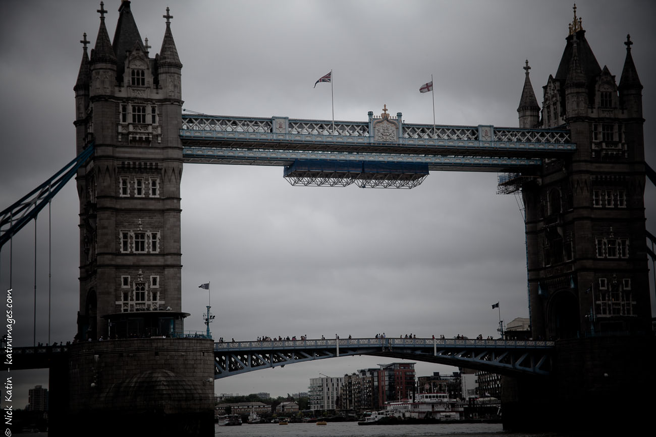
The famous tower bridge in East London, England Share this:
-
Travel different – London6

The London Eye On London’s Southbank, England © 2010 Nick Katin Part of the relativity new London overground travels from North London to Surrey Quays in East London. Actually some of the overground is underground – in fact under water through the oldest tunnel under a navigable river, the Thames Tunnel.
From Surrey Quays station it’s a short walk to Greenfields pier. One of the frequent Thames clippers ferries to the London eye, a very pleasant half an hour, 10 kilometre ride despite the gloomy dark sky and the choppy water. For £6.00 (cheaper with an Oyster card) these clippers will take you from Woolwich to the London Eye passing under several bridges including London and Tower bridges and the infamous Millennium footbridge (pictured here) stopping at several points in between. A really inexpensive way to travel and see the some of the sights of London.
Millennium Pedestrian bridge On the river thames, London, England © 2010 Nick Katin Share this:
-
Travel different – London5

Tower bridge The famous tower bridge in East London, England © 2010 Nick Katin Near the famous tower bridge is Katherine dock, supposedly one of London’s best kept secrets. The Thames path, a 294 km walk that follows the Thames (obviously) from its source in the Cotswolds to Greenwich and almost the North Sea, tracks its way through the docks with even a stop to see the boats pass through the lock.

Shadwell Basin Near Katharine dock, East London, England © 2010 Nick Katin Share this:


